 Pratiques et Techniques en Plaisance
| Imprimer |
Fermer la fenêtre
Pratiques et Techniques en Plaisance
| Imprimer |
Fermer la fenêtre
Grèce - Notices to mariners et sécurité de navigation
|
 Publié Juillet 2014, (màj Mars 2020) par :
Grèce : aides, documents et informations pour la navigation
Préambule
- Notices to Mariners C’est un avis aux navigateurs les informant de questions importantes affectant la sécurité de la navigation, y compris des modifications hydrographiques, les changements de chenaux ou d’aides à la navigation. Plus de 60 pays produisant des cartes marines éditent également des notices to mariner. Environ un tiers d’entre eux sont hebdomadaires, un autre tiers sont bimensuels ou mensuels, et le reste est émis irrégulièrement en fonction des besoins. Par exemple, l’Office hydrographique du Royaume-Uni publie des mises à jour hebdomadaires
- Navwarns regroupe des informations sur la sécurité de la navigation d’un plus faible degré de gravité. Ces éléments ne seront pas nécessairement traités par écrit, mais face à leur caractère d’urgence utiliseront d’autres supports : radio transmission, radio télétype (Navtex), téléphone.
- En France, c’est le rôle dévolu au SHOM et à ses moyens de communication : Avurnav (l’équivalent des Navwarns) traité dans le cadre de ses responsabilité sur la zone NAVAREA II : Voir note : [1]
- Au Royaume Uni, on trouvera géré par leur service hydrographique mondial : UKHO des informations couvrant le monde entier, pour les Notices to Mariners. Les Navwarns seront gérés, et diffusés, soit par Safety Net Service, soit par des annonces Navtex, soit par un site internet performant.
- Aux USA aussi bien pour les Notices to Mariners que les Navwarns édité par la NGA : https://msi.nga.mil/NGAPortal/MSI.p...
- En Grèce, plusieurs moyens pour accéder aux Notices to Mariners et aux Navwarns
- Le site officiel océanographique grec : HNHS Hellenic Navy Hydrographics Services
- Le site officiel météorologique grec : HNMS Hellenic National Meteorological Service
- Dans les deux cas, l’information la plus fiable viendra par le Navtex. Soit par un lecteur dédié (décrit ci après avec les guides nautiques) soit par un accès via Internet. Si aujourd’hui, les connexion 4G ne posent plus de problème sur cette zone, la fiabilité et la régularité des annonces Navtex peuvent en poser (c’état encore le cas en 2015, ou de nombreux plaisanciers préféraient se connecter aux sites turcs (Izmir et Antalya), plus fiables.
- Précisions pour les zones NAVAREA et METAREA ; voir ce lien : https://www.egmdss.com/gmdss-course...
Documentation et guides nautiques
Imray-Rod-Heikell / Grèce
Edition anglaise 2013
http://www.imray.com/Publications/I...
- Pas d’erreurs.
- Lacune de mise à jour :
- Edit du 10/07/2014 :
- L’accès aux données NAVTEX par le web, comporte des risques, ceux de la qualité de la connexion 3G ou wifi… La sécurité est bien sûr d’y accéder par un récepteur NAVTEX dédié… mais vous serez limité à ce seul usage
- Edit du 21/02/2020
- Rod Heikell traite les grands domaines de la sécurité : liste des stations VHF, émissions VHF, MF radio, HF radio, Navtex, RRTY, Weatherfax. Il aborde aussi la communication par Internet, mais, il a beau faire, on sent bien que c’est un peu forcé !!!
- On peut consulter les mises à jours sur le site Imray : https://www.imray.com/files/book_su...
Nicholas D. Elias
Intègre aussi des renseignements techniques dont les NAVWARNS. Ma version ancienne de ce guide n’indique pas de liens Internet. Voir leur site : https://eagleray.gr/en/
Paramétrage d’un lecteur Navtex, pour les trois stations grecques
518 KhZ ou 490 KhZ (en grec !).
0n peut filtrer sur les récepteurs Navtex les stations grecques sur le premier caractère :
- K pour Kerkira
- H pour Heraklion
- L pour Limnos
On pourrait même fournir le code du deuxième caractère qui donne le type de message, tous les messages NAVTEX ont un préfixe composé d’un groupe de quatre (4) caractères alphanumériques, B1, B2, B3, B4 :
- Le premier caractère B1 (lettre) définit l’identité de la station émettrice.
- Le deuxième caractère B2 (lettre) définit la catégorie du message (comme décrit ci-dessous).
- Les troisième et quatrième caractères B3, B4 (numériques) sont le numéro de série du message numéroté de 01 à 99. Par la suite, la numérotation recommence à partir de 01, en évitant les chiffres NAVTEX valides.
Le deuxième caractère B2 (lettre) du préfixe du message, suggère la catégorie du message où les lettres suivantes sont utilisées (caractères) :
A- Avertissements de navigation.
B- StormyWindsWarning.
C- Icereports.
D- Informations sur la recherche et le sauvetage.
E- Weatherreport.
F- Messages de service pilote.
G- Messages DECCA
H- Messages LORAN.
I- Messages OMEGA.
J- Messages STANAV.
K- Autres messages électroniques d’aide à la navigation.
L- Avertissements de navigation - en plus de la lettre A.
Z- Aucun message à portée de main.
Remerciements : sy Lysigée
Documents et informations réglementaires
L’administration grecque est handicapé par son manque de culture centralisatrice. Ses services publics manquent de fiabilité et rendent difficile la quête de renseignements. Pour adoucir la critique, on peut utiliser 4 liens directs donnant accès aux données Navetex depuis la fin du chapitre HNHS
HNHS Hellenic Navy Hydrographics Services
Ses missions

- Le Service hydrographique est l’organisme d’État possédant la compétence exclusive pour la certification, la compilation, la publication, l’achèvement et la correction des cartes maritimes officielles de la Grèce. Il gère aussi la mises à jour, la publication, l’achèvement et la correction des publications maritimes officielles.
- Il publie également sous forme imprimée et/ou électronique, des aides et instructions d’expédition, des annonces, des messages et des annonces, des prévisions de vagues et des informations océanographiques, contribuant à la promotion et au développement de la navigation et à la sécurité de la navigation.
- Enfin, il est le coordinateur national pour la gestion et l’exploitation du système NAVTEX , conformément aux lois et pratiques nationales et internationales.
Portail Internet : https://www.hnhs.gr/en/
Ses moyens de diffusion
- Pour les « Notices to Mariners », plutôt dédiés à la mise à jour de la cartographie, ils font l’objet d’une publication sous PDF.
- Remise à jour annuelle, des conditions générales d’exploitation du service
- Puis Edition mensuelle des modifications pour l’année en cours
- Archivage annuel des éditions précédentes
- Pour les « Hellenic Navwarns », informations urgentes pour la sécurité de la navigation délivrées par le Service hydrographique. S’agissant d’informations urgentes, elles ne sont pas imprimées et ne sont pas diffusées comme le sont les Notices to Mariners, mais transmises par radiotéléphonie. Concernant leur sujet principal, et aussi le mode de transmission, des informations détaillées sont disponibles dans les Notices to Mariners annuels (permanents) n ° 1 et n ° 13.
- Communication Internet : par le portail HNHS
- Communication par télephonie
- J3E type of transmission in Greek and English language by the following shore stations in areas as follows :
- ‘‘KERKYRA RADIO’’ (39° 36’ 25,7’’ – 19° 53’ 28,4’’) from the Ionian Sea until the meridian 22° 30’ 00’’ towards east (Patraikos and Corinthiakos bays included)
- ‘‘IRAKLEIO RADIO’’ (35° 19’ 19,7’’ – 25° 44’ 54,9’’) and ‘‘LIMNOS RADIO’’ (39° 54’ 24,7’’ – 25° 10’ 50,6’’) for the Aegean Sea between parallels : 34° 00’ 00’’ – 41° 00’ 00’’ and meridians 22° 30’ 00’’ – 30° 00’ 00’’.
- ‘‘RODOS RADIO’’ (36° 24’ 31,2’’ – 28° 13’ 37,1’’) for the South Aegean Sea between parallels : 34° 00’ 00’’ – 38° 00’ 00’’ and meridians 22° 30’ 00’’ – 30° 00’ 00’’.
- G2B / G3E type of transmission in Greek and English language for the Greek seas, by the following VHF transmitters of “OLYMPIA RADIO” Emitting Station
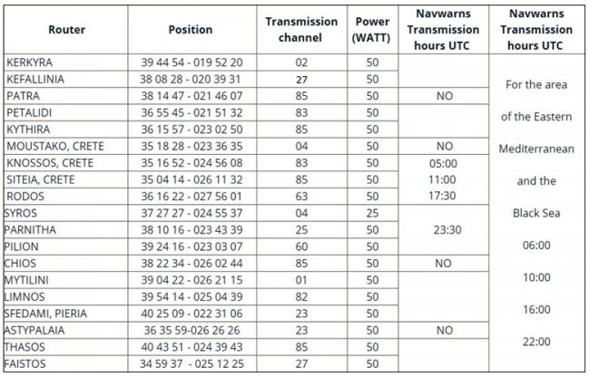
- J3E type of transmission in Greek and English language by the following shore stations in areas as follows :
- ndlr : Si vous êtes habitués à la réception des prévisions météo par VHF, vous avez fatalement remarqué ces avis, précédant la lecture de la météo, et vous aurez remarqué qu’à la vitesse à laquelle ils débitent, il n’y a rien à comprendre...
- Les Navwarns sont numérotées pour la durée de chaque année par un numéro de série de 1 et ce numéro est suivi de leur année d’émission (par exemple 1073/1999).
- Les Navwarns sont supprimées :
- Automatiquement (lorsqu’ils sont définis)
- Avec une autre annonce, avec le Navwarns pertinent (qui comprend des informations initiales plus complètes et détaillées fournies avec l’annonce), l’annonce continuera d’être diffusée pendant 15 jours, depuis la publication de l’annonce la supprimant, car on estime que dans ce délai sera achevé la dispersion de l’annonce.

- Main subject of Navwarns voir note : [2]
Navtex
- Affichage des Hellenic Navwarns en anglais
- Last NAVAREA III warning broadcasted
- Affichage des Hellenic Navwarns en grec
- Carte interactive des Navwarns en cours : https://www.hnhs.gr/geoindex/notifi...
Météorologie marine officielle
ndlr : on peut aborder les informations concernant la météo,les Notices to Mariners, et les Hellenic Navwarns par plusieurs canaux, dont une réception en télétexte du NAVTEX. Il faudra régler les accès aux stations et les paramètres pour ne pas se retrouver noyé d’informations inutiles. Aujourd’hui, l’accès à l’Internet aisé en Grèce aux connexions 4G, permet de trier l’essentiel. Deux organismes officiels grecs proposent ces services
- HNHS : le service officiel de cartographie (l’équivalent de notre SHOM), très difficile d’accès et irrégulier dans ses diffusions
- HNMS : le service météorologique officiel, beaucoup plus précis, probablement parce que géré par des militaires, pour une palette de services couvrant le secteur maritime et aéronautique, civils comme militaires, ce qui les obligent à de la précision.
HNMS Hellenic National Meteorological Service
La mission de HNMS est de fournir un soutien météorologique à la défense et à l’économie nationale, mais aussi la sécurité des personnes et des biens. Ses activités sont assurées par du personnel militaire et du personnel civil. Il participe à de nombreuses coopérations européennes et internationales. et il représente la Grèce dans de nombreuses organisations météorologiques internationales : OMM, CEPMMT, EUMETSAT, EUMETNET, ECOMET, OACI, OTAN.
Des coopérations nationales ont été établies entre le HNMS et les universités, les instituts de recherche ou les organismes gouvernementaux, le ministère de l’Agriculture et l’Agence environnementale d’Athènes. Par ces coopérations, HNMS vise à améliorer les services fournis aux clients et à promouvoir la recherche. A cette fin, il met en œuvre un système de gestion de la qualité (SMQ) documenté pour la fourniture de services de soutien aéronautique et météorologique maritime conformément aux exigences de la norme EN ISO 9001 : 2015.
Portail du HNMS : http://www.hnms.gr/emy/en/navigatio...
Rubrique 1 : Marine Warning & Forecast METAREA-3
HNMS > Marine > Partie 1 > Marine Warning & Forecast
- Zones METAREA 3
- Sea bulletin par zones
- Sea forecast par zone
- Analyse de surface et prévisions
Rubrique 2 : NWP prévisions numériques
HNMS > Marine > Partie 2 > NWP (pas 3 H - horizon 72 H)
- Vent à 10 mètres
- Hauteur et direction des vagues
- Période des vagues
- Température surface de la mer
- Prévisions par zone
Rubrique 3 : aides, tutoriels, définitions
HNMS > Marine > Partie 3 > Useful pages
- Guide to marine bulletin : terminologie des annonces météo
- Précisions des horaires de diffusion
- Précisions sur l’analyse et les prévisions
- Précisions sur les termes calendaires (very soon, soon, latter)
- Précisions sur la visibilité
- Précision sur les termes des « Warnings »
Rubrique 4 : liens externes pratiques
HNMS > Marine > Partie 4 > Useful links
- Lien vers la page de l’IMO (OHI) traitant de la convention SOLAS. En anglais, facilement traduisible en français avec le traducteur automatique google
- Lien vers la page des « Hellenics Coast Guards » (grec, anglais et traduisible en ligne en français) détaillant tous les numéros utiles pour joindre un service portuaire local, mais aussi et surtout, les liens permettant d’accéder aux numéros de téléphones, adresses e-mail et procédures d’appels d’urgence de secours. lien direct : http://www.hcg.gr/
- Lien donnant accès par Internet aux informations NAVTEX, ce qui reste le moyen le plus efficace pour afficher par zone, les « Warnings/Notices to Mariners et Navwarns » Lien direct pour l’affichage NAVTEX par Internet : https://www.hnhs.gr/en/online-2/navtex avec 3 possibilités de connexion
- « Irakleio Station » Crète et sud Égée
- « Kerkira Station » Mer Ionienne
- « Limnos Station » Nord Égée
Remerciements : Pytheas54, et sa documentation. http://www.stw.fr/forumstw/quest_an...
Michel, Laorana, juillet 2014/2020
[1] The provision of NAVAREA II warnings on this website is not intended to be a substitute for, or an alternative to, the International Safety Net service,and does not relieve Masters/Captains of their responsability to monitor MSI broadcasts in accordance with the provisions of SOLAS.
[2] 7.1 NAVAREA Warnings
(a) In general the Area Navwarns concern information regarding the safety of navigation of ocean-going vessels, in detail are as follows :
(Ι) Casualties to lights, fog signals, buoys and other aids to navigation affecting main shipping lanes.
(ΙΙ) The presence of dangerous wrecks in or near main shipping lanes and if
relevant, their marking.
(ΙΙΙ) Establishment of major new aids to navigation or significant changes to existing ones, when such establishment or change might be misleading to shipping.
(IV) The presence of large unwieldy tows in congested waters.
(V) Drifting hazards (including derelict ships, ice, mines, containers, other large items over 6 meters in length, etc.).
(VI) Areas where search and rescue (SAR) and anti-pollution operations are being carried out (for avoidance of such areas).
(VII) The presence of newly discovered rocks, shoals, reefs and wrecks likely to constitute a danger to shipping, and, if relevant, their marking.
(VIII) Unexpected alteration or suspension of established routes.
(IX) Cable or pipe-laying activities, seismic surveys, the towing of large submerged objects for research or exploration purposes, the employment of manned or unmanned submersibles, or other underwater operations constituting potential dangers in or near shipping lanes.
(Χ) The establishment of research or scientific instruments in or near shipping lanes.
(ΧΙ) The establishment of offshore structures in or near shipping lanes.
(ΧΙΙ) Significant malfunctioning of radio-navigation services and shore-based maritime safety information radio or satellite services.
(ΧΙΙΙ) Information concerning events which might affect the safety of shipping, sometimes over wide areas, e.g naval exercises, missile firings, space missions, nuclear tests, ordnance dumping zones e.t.c.
(XIV) Operating anomalies identified within ECDIS including ENC issues.
(XV) Acts of piracy and armed robbery against ships.
(XVI) Tsunamis and other natural phenomena, such as abnormal changes to sea level.
(XVII) World Health Organization (WMO) health advisory information.
(XVIII) Security-related requirements.
(b) The above signal catalogue that was sufficient checked and after their assessment broadcasted as Navwarns must be taken into consideration only as a guide.
(c) The categories of signals transmitted with the form of Navwarns must be updated every 36 months from their initial transmission. The Navwarns for the mariners, which are transmitted within the area, must be numbered successively during the year.
7.2 Coastal Navwarns
The Coastal Navwarns concern information that is mentioned in the above paragraph and they are enough for the briefing of the mariners, when entered to a subarea or to a district. Nevertheless the Coastal Navwarns must not be confined into main navigation routes only.
7.3 Local Navwarns The local Navwarns complete the Coastal broadcast/dispersal System of navigational information by providing detailed information regarding subjects which do not concern the oceangoing navigation. The local Navwarns can be issued only to the National language.
7.4 The Navwarn Area system must be adjusted as to be sufficient for vessels
navigating in the main routes of an Area. In certain sea areas the reception of
Coastal Navwarns can be proved actually necessary.
